Places
Kjerag or Preikestolen? The Lysefjord's Two Famous Hikes Compared
Kjerag and Preikestolen look down on the same fjord, but they are very different days out. Preikestolen is the shorter, gentler and much busier hike: about 8 km there and back, around 500 metres of climbing and about 4 hours, to a flat shelf 604 metres above the Lysefjord that you can reach all year, about 40 minutes by road from Stavanger. Kjerag is the bigger mountain day: about 11 km, around 750 metres of ascent and 6–8 hours for most hikers, with chains on the steepest slopes, a season that runs only from May to October, and a trailhead about 2.5 hours from Stavanger.
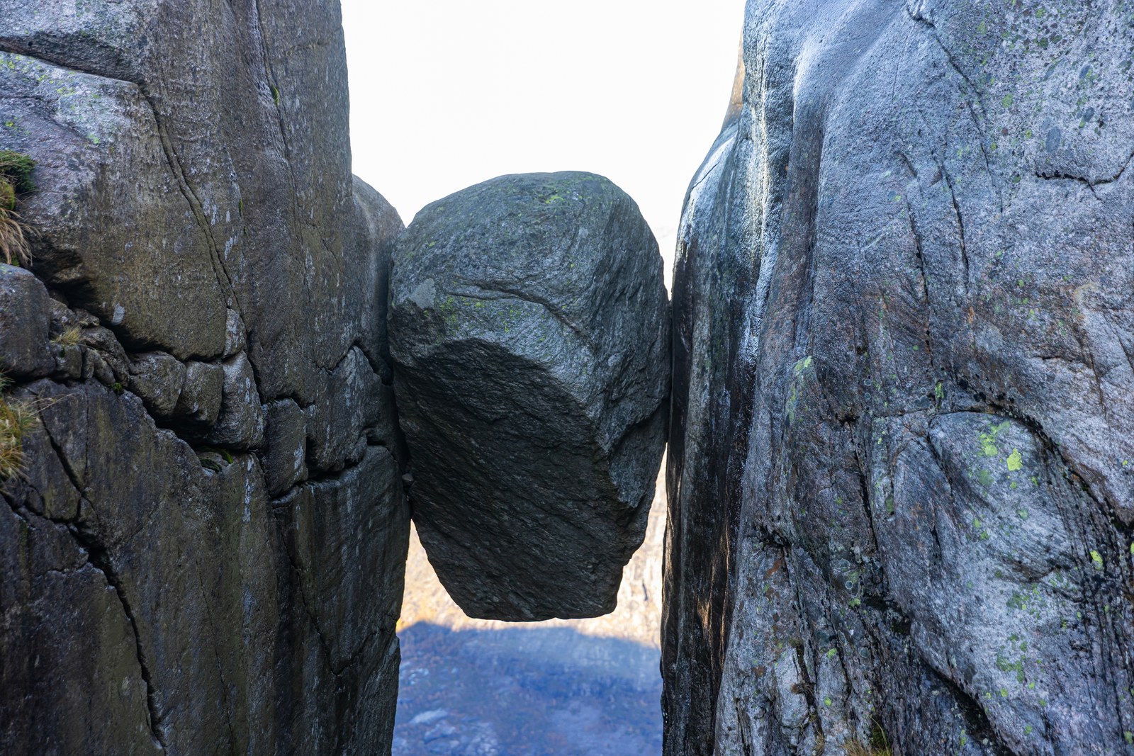
If you have one day, no car and little experience of mountain paths, choose Preikestolen. If you are fit, at ease on steep rock and visiting in summer, Kjerag is the harder and quieter walk, and it ends at Kjeragbolten, the boulder jammed in a crack high above the fjord. This article sets the two side by side.
The short answer
- Preikestolen is easier: about 8 km, around 500 metres up and about 4 hours, on a well-built path.
- Kjerag is harder: about 11 km, around 750 metres up and 6–8 hours, over steep ridges with chains.
- Preikestolen is closer: about 40 minutes by car from Stavanger, or about an hour by express bus.
- Kjerag is further: about 2.5 hours by car or by the summer bus, or a boat to Lysebotn and a shuttle.
- Preikestolen is open all year, with a guide advised in winter. Kjerag’s season is May to October.
- Preikestolen is far busier: 348,000 hikers in the summer of 2022, against roughly 50,000 a year at Kjerag.
Where they are on the Lysefjord
The Lysefjord is 42 km long and runs north-east from the Høgsfjord, east of Stavanger. The two hikes sit at opposite ends of it, on opposite shores.
Preikestolen is on the north side of the outer fjord, in Strand municipality, the end closest to Stavanger and the Ryfylke tunnel. Kjerag is on the south side near the head of the fjord, in Sandnes municipality. Store norske leksikon describes a granite massif 4–5 kilometres long whose north face drops almost 1,000 metres straight into the fjord. Below it lies Lysebotn, a power village that has supplied electricity to large parts of Norway since the 1950s and has only a handful of permanent residents.
The Geological Survey of Norway notes that from Preikestolen you can see Lysebotn, about 30 km away. Most of what follows comes down to that distance: Preikestolen is close to the city, while Kjerag is reached along the whole fjord by boat or over the mountains by road.
The two hikes side by side
| Preikestolen | Kjerag | |
|---|---|---|
| Start | Preikestolen Parking, by Preikestolen BaseCamp | Kjerag Parking at Øygardstøl, 640 metres above sea level |
| Distance | About 8 km round trip | About 11 km round trip |
| Total ascent | Around 500 metres | Around 750 metres |
| Time | About 4 hours | 6–8 hours for most hikers |
| Grade (tourism board) | Challenging (red) | Challenging (red) |
| Height of the landmark (tourism board) | 604 metres, the plateau | About 1,000 metres, Kjeragbolten |
| Chains (tourism board) | None | Several hundred metres on the steepest parts |
| Season | All year; guide advised in winter | May to October |
| Visitors | 348,000 in the summer of 2022 | Roughly 50,000 a year (tourism board) |
Rows marked “tourism board” are Fjord Norway’s figures; the rest are those of the people who manage each trail: the Preikestolen Foundation, and Lysefjorden Utvikling, the non-profit behind kjerag.info. The foundation grades Preikestolen moderate; kjerag.info calls Kjerag challenging and strongly recommends previous mountain hiking experience.
Why the Kjerag figures vary
| Source | Distance | Ascent | Time |
|---|---|---|---|
| kjerag.info, FAQ | 11 km | About 750 m | 6–8 hours |
| kjerag.info, trail page | 5.5 km each way | 750 m | 2.5 to 3 hours one way |
| Fjord Norway, Kjerag page | About 11 km | About 760 m (750 m in its facts box) | Around 6 hours |
| Fjord Norway, bus listing | Around 10 km | 570 m altitude difference | 5–6 hours |
| Go Fjords, 2026 guide | About 9.8 km | Around 460 m | 6 to 8 hours |
| Go Fjords guide on Fjord Norway’s site | 5 km each way | 600 m | About 3 hours each way |
The boulder’s height varies too: about 1,000 metres above sea level for Fjord Norway, 1,032 metres in the older Go Fjords guide, and “nearly 984 metres” above the Lysefjord in Go Fjords’ 2026 guide. Plan for the managers’ figures, 11 km and 6–8 hours, and you will not be caught short. Preikestolen has a smaller version of the problem: Go Fjords gives about 350 metres of ascent, the foundation around 500.
Getting there from Stavanger
Preikestolen: about 40 minutes through the tunnel
Preikestolen Parking is about 40 minutes’ drive from Stavanger through the Ryfylke tunnel. In the main season, express buses from central Stavanger take about an hour; out of season, the usual answer is bus no. 100 to Jørpelandsvågen and a taxi. Our guide to getting to Preikestolen has every option and price.
Kjerag: three ways in, all long
- The Kjerag express bus. Go Fjords calls its bus the only direct public transport between Stavanger city centre and the trailhead. Its 2026 schedule left Stavanger at 07:45, arrived at about 10:15, left the trailhead at 16:30 and was back at about 19:00. In 2026 it ran at weekends only in June and September, and on Tuesdays, Thursdays and weekends in July and August. Fjord Norway lists the round trip at NOK 995 for adults and NOK 525 for children aged 0–17, from Stavanger bus terminal, track 7. Tickets are sold online only, and the tour has no guide.
- By car. kjerag.info says the fastest route from Stavanger is around the mountains via Ålgård and Sirdal, about 2.5 hours, ending on the Lysevegen mountain road (Rv500 to Fjord Norway, county road 4224 to Store norske leksikon). Kjerag Parking holds up to 400 cars and charges NOK 300 for more than 2 hours, paid after the hike. Its managers say it rarely fills up; Go Fjords warns that late-morning arrivals may find it full. Sleeping in vehicles is not allowed.
- By boat to Lysebotn. Car ferries reach Lysebotn from Lauvvik, Forsand and Songesand, and passenger boats call at other quays too. From the quay it is a 7.5-kilometre drive up 27 hairpin bends to the car park, or a ride on the SBK BASE shuttle bus, which in 2026 ran from 24 May to 30 September at NOK 250 each way. The ferries have limited capacity, so pre-book.
On the bus the return time is fixed, so if you are a slow walker, the 16:30 departure is the limit to plan around, not the hike’s average time.
The trail: what each walk is like
Preikestolen. The first 500 metres climb a gravel road and gain over 80 metres. The path then crosses forest and bog on bridges, climbs the stone steps laid by Sherpas from Nepal, opens into bare rock and small lakes, and finishes along the edge above the fjord. You return the same way. Our guide to the Preikestolen hike takes it stage by stage.
Kjerag. The path is marked with red Ts and starts with a steep climb over the first mountain ridge. It drops to Litle Storedal, where you climb a steep slope again, and from the outlet of Storedalen a steep ridge leads onto the Kjerag massif, with views down onto the fjord. Go Fjords counts three long, steep climbs over exposed rock in all. Parts of the trail are paved with stones, and chains and railings protect the harder sections. On top, the landscape is barren rock and sheer cliffs. A side trail about 300 metres before the boulder leads to the Nesatindane viewpoint, a 5-minute walk from Kjeragbolten itself.
You come back the same way, and because the route climbs, dips and climbs again, there is real climbing on the way home too. As Go Fjords puts it, reaching Kjeragbolten is only halfway through the day.
Chains, exposure and the boulder
Preikestolen has steep sections and stone stairways, but most of the trail does not run along exposed edges. The exposed part is the end: the plateau has no railings or barriers, and the foundation warns that people afraid of heights may find the final viewpoint uncomfortable.
Kjerag asks more of you all the way. The steepest parts have several hundred metres of chains, and Fjord Norway’s warning is worth repeating: it can be scary to walk down these sections, so allow extra time if you are afraid of heights. kjerag.info adds that parts of the trail run close to steep cliffs and that, with a fear of heights or vertigo, Kjerag may be uncomfortable or unsuitable. The chains are removed when the road closes for winter.
Kjeragbolten is a round boulder wedged in a crevice. Store norske leksikon explains that it is a block carried by the ice, which jammed in a crack in the cliff as the ice melted; the crack beneath it is several hundred metres deep. kjerag.info is frank about stepping onto it: the boulder is extremely exposed, a fall would be fatal, and the decision is entirely yours. As far as its managers know, no one has ever fallen off, and about 45% of hikers choose not to step onto it. Do not try it with vertigo, when the rock is wet, icy or slippery, or when it is windy.
Seasons: all year, or May to October
Preikestolen can be hiked all year. June to September is the most popular period, when the trail is generally snow-free. From October to April, Preikestolen BaseCamp warns that the path is often covered in ice and snow, and the tourism board recommends a guide in winter.
Kjerag has a season, and it follows the road. When the road is closed, kjerag.info says, Kjerag is not accessible, and the trail and boulder are buried under snow. The exact dates vary by source:
- Fjord Norway: the road closes with the first snowfall, usually in October or November, and usually opens in mid-May.
- kjerag.info: the car park operates from mid-May until the end of October; its trail page says the road opens in late May; and in October 2026 its home page gave 1 May 2027 as the expected opening.
Check both before you book. Even in season, kjerag.info says Kjerag is about 10 degrees colder than Stavanger, with stronger winds, and snow can linger until mid-June and return in late September.
Crowds
- Preikestolen: 348,000 hikers in the summer of 2022, and up to 7,000 on peak summer days, by the foundation’s figures. The busiest window is 08:00 to 11:00; to beat it, start well before 07:00, or start in the late afternoon in June, July and August.
- Kjerag: roughly 50,000 people a year. kjerag.info says that on sunny weekends in June, July and August the trail can be busy, with possible waiting times at the boulder, and Fjord Norway says most visitors come at weekends in midsummer. Go Fjords’ view is that even then, Kjerag is less crowded than Preikestolen.
Safety, daylight and the people who can help
Both trailheads have hosts, and they are worth talking to. At Preikestolen the car park is staffed all year, from 07:00 to 18:00 in summer and 09:00 to 14:00 in winter. At Kjerag, the car park is staffed from 07:00 to 21:00 in high season, and its tourist information office posts daily weather and trail updates during the season.
Kjerag needs more caution than Preikestolen:
- Daylight. Do not start if there is a risk of it getting dark before you return.
- Weather. Reconsider in strong wind, heavy fog or under weather warnings; rain makes the granite slippery.
- Phones. Mobile coverage is limited and unreliable in parts of the area, especially around Kjeragbolten.
- Rescue. Operations can take several hours, and a helicopter may be delayed or unable to fly in wind or fog.
For both hikes, the Norwegian Mountain Code applies: plan your trip and tell someone your route, be ready for bad weather, and don’t be ashamed to turn around. In an emergency, call 113 for medical help or 112 for the police. Our article on Preikestolen deaths and safety covers the risks in detail.
Children, dogs, food and water
- Children: in summer, most families can complete Preikestolen safely, according to the foundation. kjerag.info does not generally recommend Kjerag for children under 8, and discourages child carriers.
- Dogs: allowed on both, on a leash at all times. At Kjerag, sheep graze in the area.
- Water: you cannot refill a bottle on the Preikestolen trail. For Kjerag the sources disagree: Fjord Norway says you can refill at Storedalen, but kjerag.info says there is no food or drinking water along the trail. Carry all you need.
- Facilities: toilets only at each car park. Preikestolen BaseCamp has a café, a restaurant and gear rental; near Kjerag Parking is the Eagle’s Nest restaurant, on a 640-metre cliff above Lysebotn.
What each view is like
From Preikestolen, you stand on an almost flat shelf of rock about 25 by 25 metres, 604 metres above the water, looking along the fjord. What you cannot see is the cliff you are standing on.
From Kjerag, you are much higher, nearly 1,000 metres above the fjord. kjerag.info says that from Nesatindane you can see the entire stretch of the fjord from Lysebotn to Preikestolen. The boulder is the photograph people travel for. In summer you may see base jumpers: the Kjerag plateau is used as a launch point, and their landing place, the Geitaneset peninsula, is visible only from Nesatindane, not from the boulder.
You do not have to climb either to see it. The sightseeing cruise from Stavanger passes beneath Preikestolen. For Kjerag you need a boat that goes on to Lysebotn: from it you can glimpse Kjeragbolten about 1,000 metres above you, and Fjord Norway’s advice is to look up as the boat approaches Geitaneset. Our Lysefjord cruise guide compares the boats.
Doing both
Not on the same day. With the Kjerag bus out at 07:45 and back at about 19:00, and the hikes at opposite ends of the fjord, two separate days is the realistic plan.
- Do Preikestolen first. If 4 hours and 500 metres felt hard, Kjerag’s longer, steeper route with chains will feel much harder.
- Base yourself in Stavanger. Hike Preikestolen one day and take the Kjerag bus on one of its running days.
- Spend a night at the head of the fjord. Lysebotn has accommodation, a campsite, a café and a country store, and kjerag.info suggests staying nearby, since the hike takes a significant part of the day.
- Walk between them. Lysefjorden Rundt is a 100 km loop in eight stages around the fjord, taking 4–8 days, and the Kjerag trail is one of its stages.
Which one should you choose?
- First time in the mountains, or with children: Preikestolen.
- A single port day from a cruise ship: Preikestolen. Most ships stay 8–10 hours, and the Go Fjords express-bus day runs from 09:00 to 16:00, about 7 hours; our guide to Preikestolen from a cruise ship does the time maths.
- Between November and April: Preikestolen, with a guide. Kjerag is closed.
- Fit, experienced and here in summer: Kjerag, ideally on a weekday, with Preikestolen first if you have time.
- Uneasy with heights: Preikestolen, keeping well back from the edge. Kjerag’s chains are hardest on the way down.
- Not a hiker: take a boat, and see both from below.
The guided hikes and cruises on our tours page are Preikestolen and Lysefjord trips from Stavanger, compared in our guide to Pulpit Rock tours. Most Kjerag hikers go without a guide in the main season, but kjerag.info advises hiring one in poor weather or if you lack experience.
Frequently asked questions
Is Kjerag harder than Preikestolen?
Yes. Kjerag is about 11 km with around 750 metres of ascent and takes most hikers 6–8 hours, over steep ridges with chains. Preikestolen is about 8 km, around 500 metres and about 4 hours.
How do you get to Kjerag without a car?
In summer, take the Go Fjords Kjerag express bus from Stavanger on the days it runs. Otherwise, take a boat to Lysebotn and the SBK BASE shuttle up to Kjerag Parking. Book both ahead.
When can you hike Kjerag?
From May to October, while the mountain road is open; it is usually closed from November to mid-May, and Kjerag cannot be reached then.
Do you have to stand on Kjeragbolten?
No. It is your own decision, and about 45% of hikers choose not to. The views from the plateau and Nesatindane are worth the walk on their own.
Can you do Preikestolen and Kjerag in one day?
Not realistically. They are at opposite ends of the fjord, and each fills most of a day once you count the travel. Plan two days, with Preikestolen first.
Which has the better view?
They are different. Preikestolen is a flat platform 604 metres above the fjord; Kjerag puts you nearly 1,000 metres above it, with the boulder as the centrepiece.