Preikestolen Hike: Distance, Time, Difficulty and When to Go
The hike to Preikestolen is about 8 km there and back, with a total climb of around 500 metres, and takes about 4 hours for most people. The Preikestolen Foundation, which manages the trail, grades it as moderate; the regional tourism board rates it red, or challenging. Both are fair: it is a proper mountain walk with steep sections and stone stairways, but the path is so well built that most people reach the top.
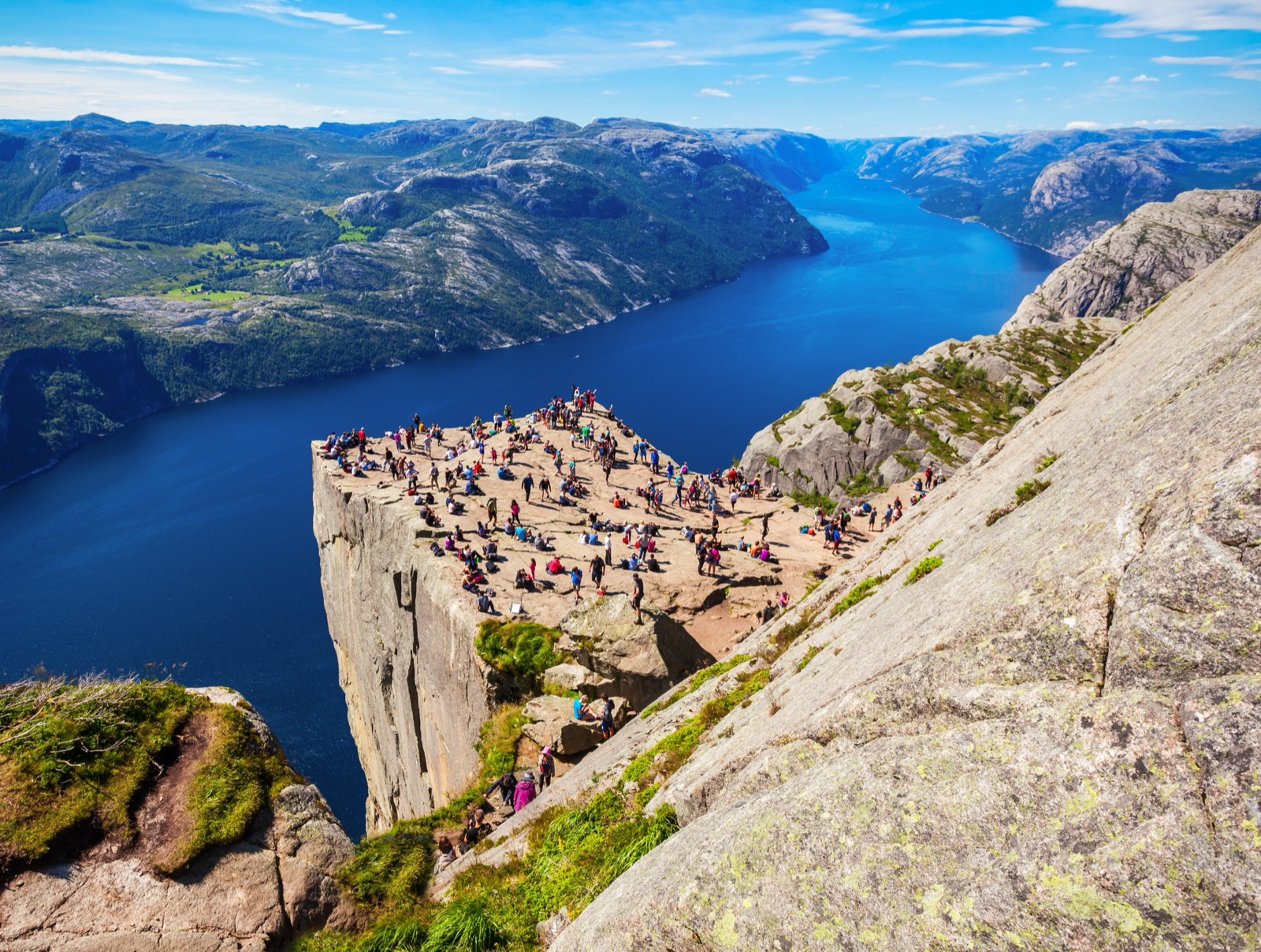
At the end is the plateau itself, a flat shelf of rock only about 25 x 25 metres that rises 604 metres above the Lysefjord. You can hike it all year, but the experience changes completely with the season, and in winter the advice is to go with a guide. This guide covers the route stage by stage, how hard it really is, when to go, how to avoid the crowds, sunrise and winter hikes, and what to bring.
The hike in numbers
| Distance | About 8 km (5 miles) round trip, 4 km each way |
| Total ascent | Around 500 metres |
| Time | About 4 hours round trip; around 2 hours each way |
| Grade | Moderate (trail managers); challenging, red (tourism board) |
| Start and finish | Preikestolen Parking, next to Preikestolen BaseCamp |
| Lowest and highest point | 270 metres and 604 metres above sea level |
| Season | All year; most popular June to September |
| Facilities | Toilets and food at the car park only |
A note on the figures
You will see different numbers quoted. Go Fjords, which runs one of the express buses, gives the elevation gain as about 350 metres. The trail managers and the tourism board both give around 500 metres, and this guide follows them. Time estimates also vary: the bus operator Pulpit Rock Tours allows 3–5 hours for the walk from BaseCamp and back, and a guided winter hike plans 2–3 hours each way. The honest answer is that 4 hours is the norm and slower walkers should plan for more.
Getting to the start
The trail starts at Preikestolen Parking, next to Preikestolen BaseCamp, about a 40-minute drive from Stavanger through the Ryfylke tunnel and a 10-minute drive from Jørpeland. In the main season, express buses from central Stavanger take about an hour and drop you at the start of the trail; out of season the direct buses stop. Parking for the day costs NOK 275 for a car, as published by the trail managers. Our guide to getting to Preikestolen compares every option, including the boat.
The route, stage by stage
The walk starts from the fee-based car park, beside the service building with toilets. It is an out-and-back route: you return the way you came. Preikestolen carries the National scenic hike label, given to trails planned to cope with very high visitor numbers, and in 2020 the route of just over four kilometres was certified as a national scenic trail.
The first climb. The first 500 metres follow a winding gravel road and gain more than 80 metres. It is a steep start and a good test of how the rest of the day will feel.
Forest and bog. The trail then levels out a little before climbing steadily onto the mountain. It crosses swampland and forest, with bridges over the wettest sections.
The Sherpa steps. On the steepest and most demanding parts, the path is built as stone stairways. Sherpas from Nepal were brought in to improve the trail, clearing boulders from several of the steeper sections and laying the steps; the tourism board points out that the work makes the hike easier while also protecting the ground around it.
The lakes. Higher up the terrain opens into smooth rock and small lakes. Tjødnane, about 1 kilometre before Preikestolen, is a good place for a meal break, and on a warm day for a dip in the small lake.
Along the fjord. The last stretch runs along the edge above the Lysefjord. Part of the trail here goes alongside high cliffs, which matters if you are walking with children. Then the plateau comes into view.
The route is easy to follow. Stay on the marked trail and follow the signs and the red T markings; Go Fjords also notes red-painted distance markers along the way.
How hard is it, really?
The trail managers describe uneven terrain, stone stairways, rocky paths and some steep sections, and recommend sturdy footwear and some basic hiking experience. The tourism board puts it neatly: the hike is long and demanding enough to give experienced hikers a sense of achievement, but the path is so well prepared that most people can reach the top.
What that means in practice:
- You need to be reasonably fit, not athletic. The ascent comes in several steep sections rather than one long climb, so you can rest between them.
- Footwear matters. The terrain is rough and, when wet, slippery; sturdy boots with ankle support make the descent much easier.
- It is not accessible. The trail is not suitable for strollers, wheelchairs or people with reduced mobility.
- Fear of heights is manageable on the trail. Most of the route does not involve exposed edges; the plateau at the end is the exposed part.
On the plateau: edges, the crack and safety
The plateau has no railings or barriers at the cliff edge. Keep a safe distance from the edge, supervise children closely and avoid risky behaviour for photographs.
Many visitors notice the crack that runs across the top. Geologists have regularly measured the stability of the rock since the 1990s, and the Lysefjord’s own heritage site notes that the crack does not run all the way through the formation and is not widening.
A few rules apply at the top and on the trail:
- Drones are prohibited.
- No camping on the plateau, and no fires during the bonfire ban from 15 April to 15 September.
- Dogs are allowed, on a leash at all times, though because of the crowds the trail managers do not recommend bringing them in summer.
- In an emergency, call 113 for medical help or 112 for the police.
Before you set off, tell someone your plans and when you expect to be back.
When to go
You can hike to Preikestolen all year round, and the trail managers describe the seasons like this:
- June to September is the most popular period, when the trail is generally snow-free and conditions suit most hikers.
- May brings fresh spring colours.
- September and October are popular for autumn colours and fewer visitors.
- February and March can bring spectacular scenery with snow and ice.
- November to January is usually very quiet.
The tourism board gives the peak season as April to October. Either way, summer is busy: in the summer of 2022, 348,000 people hiked to Preikestolen, and Store norske leksikon calls it the most walked of all marked mountain routes in Norway.
From September through March the days are short. Start early and plan to be back at the car park before dark.
Beating the crowds
In summer the trail is busy, and the busiest hours are predictable. Many visitors aim for an early start, which creates a crowd peak between 08:00 and 11:00. To get ahead of it you need to start well before 07:00.
The alternative is to go late. In summer, daylight lasts long into the evening, and in June, July and August a late-afternoon start can give you a quiet, uncrowded hike. The car park is busiest from 8 am to 4 pm, especially at weekends.
Other ways to thin the crowds:
- Go on a weekday. Saturday and Sunday are the busiest days.
- Go out of season. From October to May, visitor numbers are usually very low.
- Check before you leave. Preikestolen365, the trail managers’ site, publishes a visitor forecast and trail conditions.
Sunrise hikes
Watching the sun come up over the Lysefjord from an almost empty plateau is the reason sunrise hikes exist. You can do it on your own — the car park is open 24 hours a day — or with a guide.
A guided sunrise hike listed by the tourism board gives these figures: 4.0 km each way, 2 to 3 hours each way, from 270 metres to 604 metres above sea level, with a season from May to September. Lunch is not included, and everyone carries their own equipment.
If you go on your own, remember that you will be walking the first part in the dark. Bring a torch, warm layers for the wait at the top and enough food and water, and check the weather before you leave. In midsummer, sunrise is very early indeed, so check the exact time for your date.
Hiking Preikestolen in winter
The trail is open all year, but winter is a different hike. Preikestolen BaseCamp counts the winter season as October to April, when the path is often covered in ice and snow. The trail can be slippery, the days are short, and conditions change quickly.
The advice from the people who know the trail is consistent:
- Go with a guide if you are not experienced in winter conditions. The tourism board recommends a guide in winter, both for safety and for the local knowledge, and the trail managers recommend guided hikes for anyone unfamiliar with winter hiking.
- Use spikes. Use or rent crampons or spikes, especially when the car park staff tell you to.
- Dress for winter. Wool base layers, a hat and mittens.
- Leave small children at home. The trail managers advise against hiking with children younger than 5 in winter.
Getting there is harder too: the direct buses do not run in the low season. Our guide to getting to Preikestolen covers the bus-and-taxi alternative.
Guided hikes: what you get
Guided hikes are the simplest way to do Preikestolen if you have no car, are visiting in winter, or simply want someone else to handle the logistics. They come in a few forms.
Guided winter hikes. One winter hike listed by the tourism board picks up at your accommodation at 7:00–7:15 am, drives about 40 minutes to the trailhead and allows 2–3 hours to reach the plateau and the same back. Snowshoes or spikes are provided if conditions require; hiking boots are required and can be rented. Food and drink are not included, and the standard group is up to 8 people.
Private guided hikes. A private hike with hotel or cruise-port pickup normally lasts 6–8 hours including transport from Stavanger, at a pace set by your group. No previous hiking experience is required.
Cruise and guided hike. In winter, Rødne Fjord Cruise combines a Lysefjord cruise with a guided hike, with spikes, poles and a head lamp included. Our guide to the Lysefjord cruise and Preikestolen has the details.
The tours page lists guided hikes and transfers you can book.
What to wear and bring
The weather on top is often colder and windier than in Stavanger; the tourism board warns that there is often a chilly breeze at the top, even in summer. The trail managers recommend:
- Above-ankle, waterproof hiking boots, for wet rock and mud.
- Waterproof and windproof jacket and trousers, and spare clothes.
- Enough food and water. You cannot refill a water bottle along the trail.
- A map, a mobile phone and a torch, especially outside summer.
- In winter: wool base layers, a hat, mittens and spikes for your shoes.
If you arrive without the right kit, the Preikestolen BaseCamp Adventure Center rents hiking boots, spikes, warm clothing and backpacks all year. Equipment cannot be reserved and does not need to be booked; you simply go in before your hike. BaseCamp also rents ice cleats and poles with spikes, and Go Fjords notes that shoe spikes can be rented at the kiosk near its bus drop-off.
The Norwegian Mountain Code
Norway’s Mountain Code, Fjellvettreglene, was created by the Norwegian Trekking Association (DNT) and the Norwegian Red Cross. It is written for every kind of mountain trip, and several of its rules fit Preikestolen exactly:
- Plan your trip and tell others your route. Leave word with someone about where you are going and when you expect to be back.
- Be ready for bad weather, even on short trips. The weather changes quickly in the mountains; bring extra clothing.
- Don’t be ashamed to turn around. If the weather closes in, the trail is icy or someone in your group is struggling, the plateau will still be there another day.
The rules sound obvious. They matter most on a trail as popular as this one, where it is easy to follow the crowd rather than read the conditions.
Checking conditions before you go
Conditions at the trailhead can be very different from those in Stavanger, so check them on the day:
- Ask the staff. The car park is staffed all year, and the hosts there know the state of the trail. If they tell you not to go without proper gear, take the advice.
- Look at the webcam. Preikestolen BaseCamp’s website has a webcam that shows conditions at the trailhead in real time.
- Read the forecasts. Preikestolen365 publishes trail conditions and a visitor forecast, which helps you pick a quieter time to start.
Facilities and rules at the trailhead
Everything you need is at the bottom, and nothing is at the top.
- Toilets: only at the parking area. There are no toilets or rubbish bins along the trail, so take everything back with you.
- Food: BaseCamp has a café and restaurant, and there is a kiosk where the bus stops. There are no facilities along the trail itself.
- Staff: the car park is staffed all year. Ask them about the conditions on the day, and listen to their advice.
- Overnight: sleeping in vehicles at the car park is not allowed.
Hiking with children
Plenty of families do this hike. The trail managers’ view is that in summer most families can complete it safely, while in winter hiking with small children or babies is not recommended, and not at all with children under 5.
Two things to plan for:
- The cliffs. Part of the trail runs alongside high cliffs, and the plateau has no railings. Keep children close on the final stretch and at the top.
- Child carriers. Children in carriers sit still and cool down much faster than the adults carrying them. Dress them more warmly than you think you need to.
Where to stay near the trailhead
Staying at the trailhead turns Preikestolen into an easy early or late hike. Preikestolen BaseCamp offers a mountain lodge, the old tourist cabin, glamping by the water and a private beach cabin, and overnight guests park free. The first Preikestolhytta was built here by Stavanger Turistforening in 1949; the new Preikestolen Mountain Lodge opened in 2008. For tents and campervans, Preikestolen Camping is a few kilometres away.
Frequently asked questions
How long is the Preikestolen hike?
About 8 km round trip, 4 km each way, with a total ascent of around 500 metres. Most people take about 4 hours there and back.
Is the Preikestolen hike difficult?
It is graded moderate by the trail managers and challenging by the tourism board. Expect steep sections, stone stairways and uneven ground; you need sturdy shoes and reasonable fitness, but most people reach the top.
Can I hike Preikestolen in winter without a guide?
It is possible, but the trail is often icy from October to April and both the tourism board and the trail managers recommend a guide if you are not experienced in winter conditions. Use spikes in any case.
Are there railings at the top?
No. There are no railings or barriers at the cliff edge, so keep a safe distance and watch children closely.
When is the best time to avoid the crowds?
Start well before 07:00, or in June, July and August start in the late afternoon. Weekdays are quieter than weekends, and from October to May visitor numbers are usually very low.
Can I bring my dog?
Yes, dogs are allowed on the hike, but they must be on a leash at all times. Because of the number of hikers, the trail managers do not recommend taking dogs in summer.